Tropical Storm Barry Friday Morning Update
The National Hurricane Center has released it's 4 AM CDT update on Tropical Storm Barry. Here are the particulars of the storm:
SUMMARY OF 400 AM CDT...0900 UTC...INFORMATION
----------------------------------------------
LOCATION...28.1N 90.2W
ABOUT 95 MI...155 KM SW OF THE MOUTH OF THE MISSISSIPPI RIVER
ABOUT 125 MI...205 KM SSE OF MORGAN CITY LOUISIANA
MAXIMUM SUSTAINED WINDS...50 MPH...85 KM/H
PRESENT MOVEMENT...WNW OR 295 DEGREES AT 5 MPH...7 KM/H
MINIMUM CENTRAL PRESSURE...1000 MB...29.53 INCHES
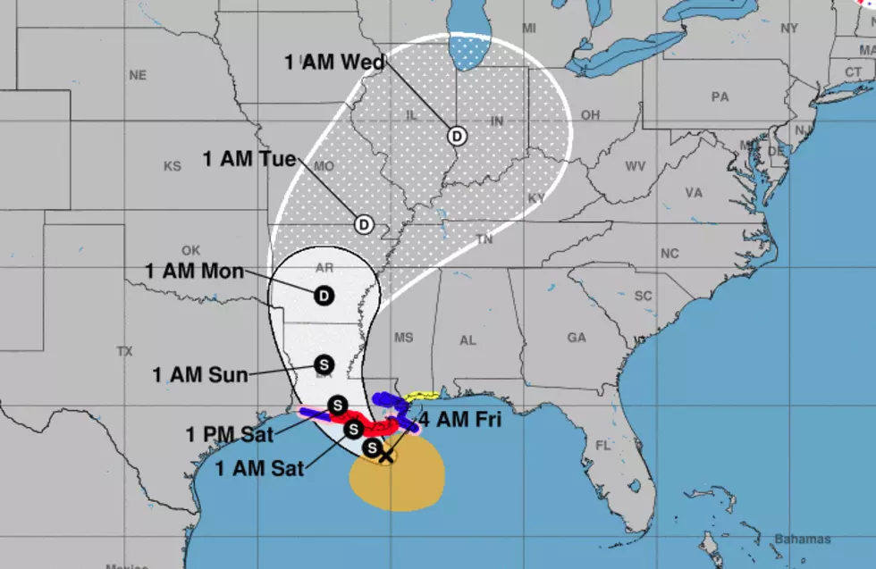
Based on Hurricane Center guidance the storm is forecast to make landfall Saturday morning near Morgan City. The official forecast does not call for the storm to reach hurricane status but forecasters say that is still a possibility just before landfall.
Following the anticipated early Saturday landfall the latest track forecast puts the center of circulation very near Lafayette by 1 PM on Saturday. This could mean winds gusting well over tropical storm strength, heavy rains, and possibly tornadoes near and to the east of the storm's center of circulation.
While gusty winds will certainly pose a problem the biggest threat from Tropical Storm Barry will likely be heavy rain and flooding. Here are the latest rainfall estimates from NOAA's Weather Prediction Center:
Based on this graphic rainfall totals across Acadiana will range from four inches to ten inches. The larger amounts will likely fall near and to the east of the center of Barry's circulation.
Current radar and satellite signatures show that Barry is a very asymmetrical storm. With most of tropical storm force winds found on the eastern side of the storm. Forecasters also say the circulation center of the storm remains very broad as it moves slowly to the west-northwest. The storm is expected to take a more northerly turn later today and Saturday.
Once Barry makes landfall the system is expected to weaken steadily as it moves in a northerly direction away from Acadiana.
More From 103.3 The GOAT


![Hurricane Barry Heats Up in Morgan City [VIDEO]](http://townsquare.media/site/36/files/2019/07/Screen-Shot-2019-07-13-at-12.39.20-PM.png?w=980&q=75)


